


47 Oberer Ringweg-52 Steinbruch


Length 8.3 Km

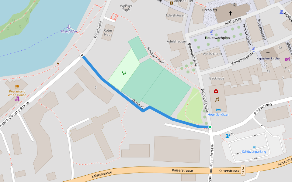
Oelwegli
Length 0.2 Km
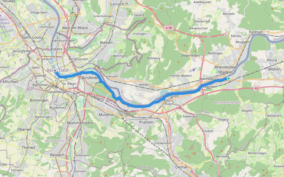
ViaRhenana - Etappe 10
Length 18.6 Km
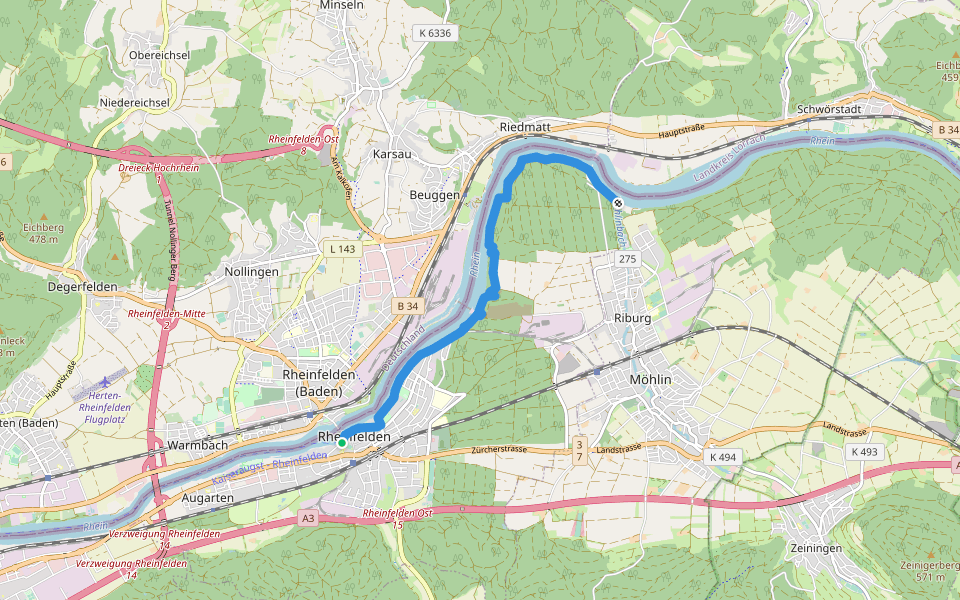
Rheinfelden - Bachtele
Length 6.8 Km
markierter Wanderweg
Galgen - fixme
Length 2.2 Km
markierter Wanderweg
Rehinfelden - ?
Length 0.2 Km
Rottannenweg
Length 7.0 Km

Riverside walk
Length 4.6 Km
Rosshimmelweg - Zeiningerweg
Length 4.2 Km

Saline Riburg - Riburgerstrasse
Length 5.7 Km
Friedensweg
Length 2.6 Km

Magden - Rheinfelden
Length 5.6 Km

Rhein River / Golf Course
Length 5.0 Km

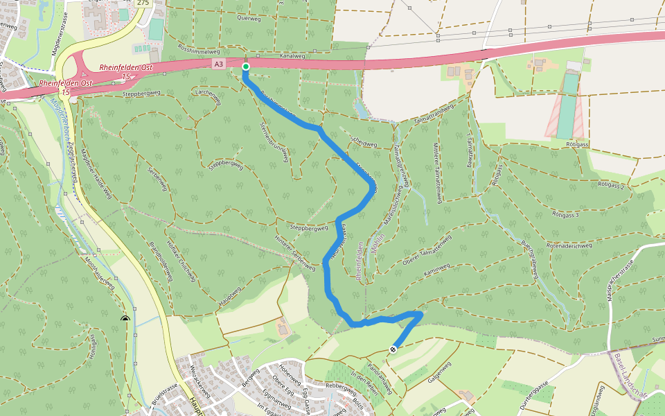
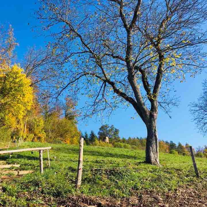
Eremitage roundtrip
Length 5.8 Km
The trail starts on the K497 road and goes around the forest area and ends on the same point Eremitage Rheinfelden making it a round trip. The walk begins at the bus stop and enters Steppbergweg trail on the other side of the road. The walk throught the forest trail is steep and uphill at some points. The trail then turns left to Lärchenweg and then leads to Rosshimmelweg on right. Then it leads to Mareislilochweg and around 2 kilometrs a small pond and a picnic area can be seen. There are many chairs to sit through out the trail. After 3 kilometrs it leads to Neui-Wert-Weg and then to HintererSerbenweg. The trail then goes to Brandweg leaving the forest area and then to Hauptweg leading to the valley. After reaching down the trail goes to 1 Weg on right and then finally reaches the Steppbergweg where the trail started. A small stretch on the 1 Weg is hard to walk or climb as it is too steep. Its really difficult even to find the trail on that area. Instead one can take the 2Weg trail and reach on the same area instead. This small area on 1 Weg makes it difficult to use strollers or wheel chairs.
Gasweg Chlosters Roundtrip
Length 8.4 Km
This trail starts on Römerstrasse and ends on the same place it started making it a round trip. At the beginning the trail is flat and easy to walk. Then it leads to Gasweg and enters the forest path which is an easy slope uphill. After the first kilometer the trail turns left to challerenweg, and becomes wide. A small pond can be seen around 1.5kilomerers. The first 3 kilometers is through the forest. Throughout the path is muddy and pebbly and a bit difficult to walk in rainy/winter seasons. Around 2 kilometers the trail leads to 52Steinbruch and after 2.5kileters turns right to Chrützhaldweg. There are many places to sit and the forest is really beautiful with coloured leaves in autumn. At 3 kilometers the forest trail ends and leads to Hagermatt valley. From there path takes left turn to Schofraidbordweg. The view from there is amazing. The trail takes left turn to Bündtenweg before the path leads to Chlosters. The trail takes a right turn after 4 kilometers to 58Leimgrube which leads to a farm and animals like sheeps, Lamas and Donkeys can be seen on right side. From there it goes left to Buchenweg and then leads to 47Oberer Ringweg. After 6.5 kilometers the trail leads to Tannenkopfweg and then Tannenkopfhaldenweg. Around 8kilometrs the trail turns left to Klappermatliweg and which finally leads to the starting point of the trail. The path is stroller friendly only in dry seasons and only big hiking strollers can be used. Throughout the path benches/chairs are present and some picnic spots also can be found.
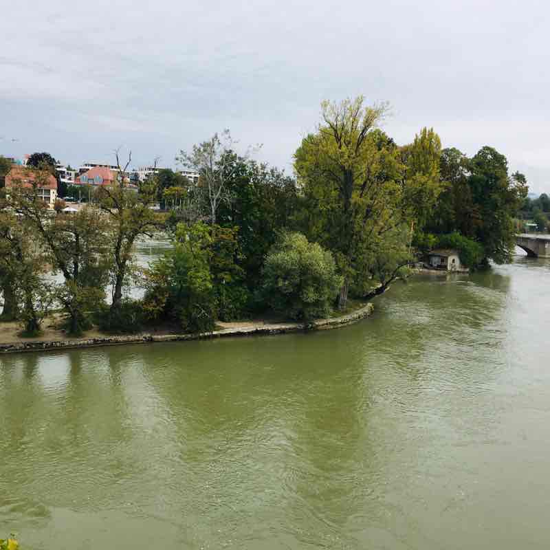
Rhine Walk
Length 5.5 Km
This is a nice walking trail for family with kids. The trail runs along the river Rhein and covers many parks/Playing areas for kids. The trail starts on the pedestrian way near Baselerstrasse and ends near Alte Saline. The first 1 km is almost flat and the river is clearly visible only after fall season/winter as bith sides of the path is covered with tall trees and bushes. But after half kilometers a small trail runs down to a shallow area by the river where kids can play in the water and is good for picnic. After 1 km a small vegetable farm can be seen on right side and the trail runs down where we can touch/get in the water. There are many areas with steps to get in the water for swimming throughout the trail. The next 1 km, there are some steps to climb up and down the trail which makes it stroller/wheelchair non friendly. After 1.3 km, the trail leads to a private area/Outdoor swimming pool where people can walk only during cold seasons as the swimming pool is closed at that time. In summer the way is closed and people can take another trail that goes around the pool and reach the same trail. After this the trail becomes narrow many times. There are many fishing areas throughout the trail. At around 1.8km the trail is too narrow and steep till 2 km. Around 2.75kms the trail runs through the old town Rheinfelden called Altstadt. This area is stroller/wheelchair friendly till the rest of the trail. From Altstadt if you take a left turn, a bridge to a river island called Inseli can be seen. This is a common swimming area in summer. A small park is also present. The bridge finally leads to Deutschland. But the trail goes straight through the old town. There are shops and restaurants on both sides till 3.2 kilometers. After that the trail leads to Stadtpark where there are many activities for kids and families. In the middle of the two areas of the Park, there is hotel and the trails runs just behind the hotel and its again a private area, but pedestrians can walk freely. After the hotel there is a big swimming area next to the park. After the park, the trail is wide and beautiful view of the river on oneside many houses on other side can be seen. The trail then leads to a housing area and finally enters the alte saline wald/forest area.
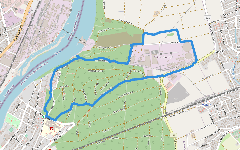
Other Saline
Length 5.7 Km
This is a round trip around the Alte Saline. The trail starts and ends on the same road. At first the trail goes through the forest and then leads to a housing area. After that the path enters the forest again and runs along the Rhine river. There are many ‘view points’ with chairs where you can sit and enjoy the view. The first part of the hike not suitable for strollers/wheel chairs. But an alternate parallel trail which is suitable for strollers and wheel chair runs along the trail. After 2 kms the path reaches an open area where you walk around the Saline Riburg and reaches another trail in the same forest again. The walk is almost easy and flat with no obstacles along the route. But a small portion of the trail is on a road without pedestrians way and need to be walked carefully. It is very quiet and calm in the forest but the grassland around the Saline is quite windy and thus noisy.
Römerstrasse-Friedenweg
Length 2.6 Km
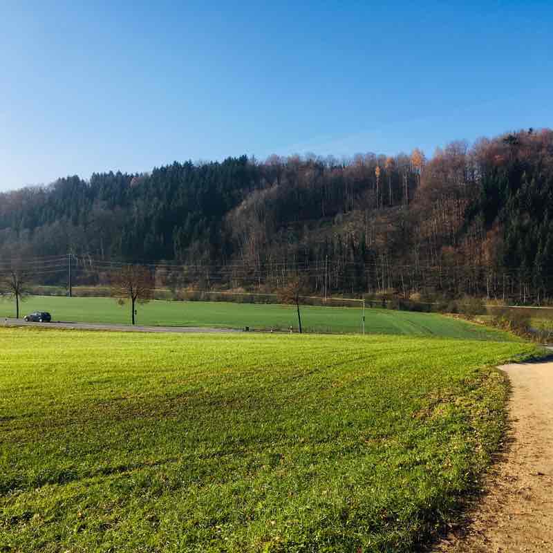
Small easy hiking trail along highway A3. First half of the trail is paved road, flat and easy to walk. After 1 km taking a U turn it enters the forest and finally reaches back to the same road. It is just 2.5 km and easy to access. Many benches can be seen to sit and enjoy the view. First part of the path is next to busy highway and thus a bit noisy, but all quiet and calm after entering the forest. It can be muddy when it rains. Wild flowers and tall trees are on both sides. A small farm with apple, cherry trees and sheeps, can be seen on one side.
Olsbergerstrasse tour
Length 6.3 Km
The trail starts at Olsbergerstrasse and ends on the same pedestrian road making it a round trip connecting Rheinfelden, magden and Rheinfelderberg. First 1 km of the trail is a paved pedestrian road along the main road. The walk starts crossing a beautiful stream. It is flat and easy to walk. Beautiful valleys on one side and the forest on the other side can be seen. The next 1km of the path is through the forest and need to be climbed uphill which is a bit hard. The trail is through the woods with lots of wild flowers and big trees on both sides. It is stroller/wheel chair friendly but the small pebbles and muddy puddles make it a bit difficult to walk. After that the path is almost flat except some areas of the trail with slopes. There are some areas in the forest where the mobile signal goes weak or no service at all, especially after 4kms. Throughout the forest is shady and cool. A lot of insects can also be seen. The chirping of birds and cool breeze makes the walk a relaxing experience. Throughout the trails bench/chairs can be seen to sit and enjoy the beauty of the trail. During autumn season the view is amazing with bright foliages. Last 2kms of the trail is almost straight and downhill. The path name boards can be seen throughout the walk which makes it easier to find the way. The path ends just 200mts away from the starting point which is on the same road.

Bergweg- Chloster- Kaiseraugst
Length 7.7 Km
At the beginning the trail runs through forest and then leads to hilly areas with farms. You can see farm animals too. In many places you can skip the main trail and walk through the woods. Tall trees, wild flowers and fern can be seen throughout the forest.

 5.0 · 1 Review


