


東村山中央公園


Length 0.8 Km

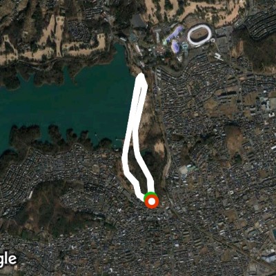
Lake Tama promenade, cherry blossom corridor
Length 14.0 Km
遊歩道の両側に桜並木が続き、途中途中に小さな公園があり、道を歩く人、自転車で走る人、誰でも桜に囲まれて気持ち良いです。

A circuit around the lake
Length 21.1 Km
途中、湖までは桜🌸の回廊です。新青梅街道のトンネルを過ぎて少し行くと、左手に富士山が見える箇所があり、さらに300mほど先、道路が横切っている側に、手打ちウドンで有名な店があったりしながら進んで行くと、東大和駅の側に着き、いよいよ登りになります。堤防までが最初のキツい登りで、その先から15分程、左右に蛇行しながらアップダウンしながら登って行き、大きく右に曲がってからは、緩やかな下りになり、一気にスピードアップ出来ます。西側の堤防の上に架かる橋の上から見る富士山は、なかなかです。更に進んで行くと左手に西武ドームを間近に見ながら、最後の登りをやっつけて行くと、西武遊園地が見えて来て、東側の堤防に到着です。これで狭山湖一周が完成です。堤防からの眺めをゆっくりと堪能してください。

Sayama Park
Length 9.7 Km
Lake Tama circuit (clockwise)
Length 11.9 Km
多摩湖堤防から天気が良ければ富士山🗻が眺められ、都心の方向には遠くスカイツリーも見えます🙂
多摩湖周回路は、あまり広くなく、サイクリング🚴♂️の方で飛ばす方もあり、左側通行厳守です🙂
多摩湖周辺の森からは、春と秋には色々な鳥のさえずりがが聞こえます🙂
途中で鹿島休憩所から多摩湖橋まで上池堤防をショートカットすることもできます🙂

Higashimurayama Chuo Park
Length 8.1 Km

東村山中央公園
Length 1.9 Km

美住緑道
Length 0.4 Km


 5.0 · 1 Review


